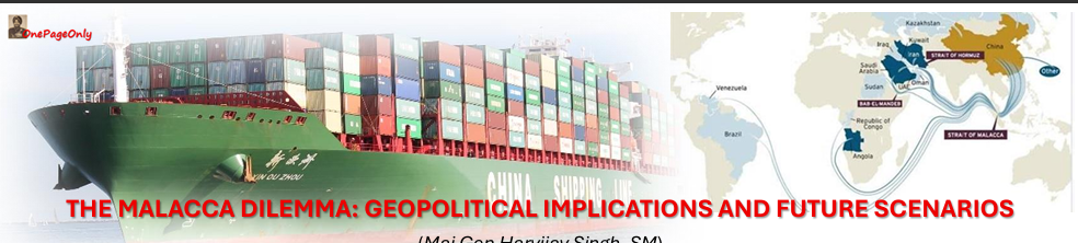

The Malacca Dilemma poses a strategic chokehold on China’s energy security, trade resilience, and geopolitical manoeuvrability. The Malacca Dilemma connects with China’s heavy reliance on the Strait of Malacca—a narrow maritime chokepoint between the Indian Ocean and the South China Sea. Why does it matter? • 80% of China’s crude oil imports pass through the strait. • Handles 25% of global maritime trade – one of the world’s busiest & most strategic sea lanes. • At its narrowest, it is just 2.5 Kms wide, making it highly susceptible to blockades/disruptions. Chinese Strategy to Mitigate the Challenge: • Diversifying energy routes: Pipelines from Russia, Central Asia, and Myanmar. • China-Pakistan Economic Corridor (CPEC): Links Gwadar Port to Xinjiang. • “String of Pearls” – Establish port access across the Indian Ocean (e.g., in Sri Lanka, Pakistan, and Djibouti) to secure maritime interests. • Naval modernization: Blue-water capabilities to project power and protect sea lanes. A snapshot Chinese Navy composition as of 2025: • Aircraft Carriers – 3 (Liaoning, Shandong, Fujian), Destroyers: 72, Frigates: 45, Corvettes: 72, Amphibious Assault Ships: 105, Mine Warfare Vessels: 64, Other Support Vessels: 127, Submarines: 74 (Mix of nuclear and conventional, including ballistic missile subs ((SSBNs – Ship Submersible Ballistic Nuclear)) and attack subs) Chinese navy’s production pace rivals that of entire Western navies annually – a force to reckon with. Nevertheless, to defend the Malacca Strait in case of hostile action would prove extremely difficult for China ……. just reaching the area of the strait would be challenging for the Chinese Navy whose nearest naval bases is Yulin Naval Base on Hainan Island, which is over 2,000 km away from the Strait. This makes overseas ports/bases vital for forward deployment. Two in the making are: Kyaukpyu in Myanmar 500 Kms from the strait, also provides a land route bypassing Malacca, and Ream in Cambodia. In addition, China can use the forward bases at Woody and Spratly Islands in the South China Sea 1800 and 1200 Kms away respectively. Strategic Implications for India Distances to the Strait of Malacca Location Car Nicobar Port Blair Visakhapatnam Distance ~ 500 Km ~1,168 km ~2,380 km Ship time to Malacca Less than a day 1.5 to 2 Days 4 to 5 Days While Car Nicobar is the forward sentinel of India’s Maritime security, the under construction Great Nicobar Island is a logistic hub and a maritime fortress (Project worth around Rs 80,000/- Cr.) India can credibly threaten the Malacca chokepoint or conduct Sea Lines of Communication (SLOC) interdiction if required—especially in conflict scenarios involving China. Note: As of now it is ‘credible’ not ‘absolute’. India’s maritime reach is like a trident with Arabian Sea, Bay of Bengal, and Andaman Sea forming its three prongs, each piercing into critical SLOCs. How it is likely to unfold • Bay of Bengal and Andaman Sea o Port Blair (Andaman Nicobar Command) and the Nicobar Islands are forward deployed for speed and rapid response. o Visakhapatnam (Easter Naval Command) offers depth, deterrence, and sustainment. It is also a deep strike launch pad for nuclear powered submarines (SSBNs/SSNs) and a hub for logistics, shipbuilding, and maintenance. • Arabian Sea o Western Naval Command at Mumbai, INS Jatayu at Minicoy and INS Kadama at Karwar handle strategic interests in the Arabian sea and SLOCs from the strait of Hormuz and the Persian Gulf to China and SE Asia. Emerging Multilateralism • Quad & AUKUS: These groupings aim to ensure a free and open Indo-Pacific, implicitly countering Chinese maritime dominance. • Indian Ocean Rim Association (IORA): Promotes regional cooperation, though its security role remains limited.